Geofence
This page documents the geofence configuration.
Configuration file fields
This section is autogenerated from the Rule Schema file.
Geofence geofence
Geofencing configuration. Define up to four circular geofence areas
Type |
Max items |
|---|---|
array |
4 |
Item geofence.item
Latitude of the circle center (-90 to 90 deg) geofence.item.lat
Type |
Default |
Minimum |
Maximum |
|---|---|---|---|
number |
0 |
-90 |
90 |
Longitude of the circle center (-180 to 180 deg) geofence.item.lon
Type |
Default |
Minimum |
Maximum |
|---|---|---|---|
number |
0 |
-180 |
180 |
Radius (m) geofence.item.radius
Radius of the circle (m)
Type |
Default |
Minimum |
|---|---|---|
integer |
0 |
0 |
Configuration explained
This section contains additional information and examples.
The CANedge2 GNSS supports up to four circular geofences with configurable radiuses[1]. When enabled, the device continuously calculates if the current position is inside or outside each of the configured fences. See GnssGeofence signals for more information on the generated output.
Note
Calculating the result of geofences on the device allows for the signal to be used as Control Signal.
Examples
Four geofences are configured as illustrated below.
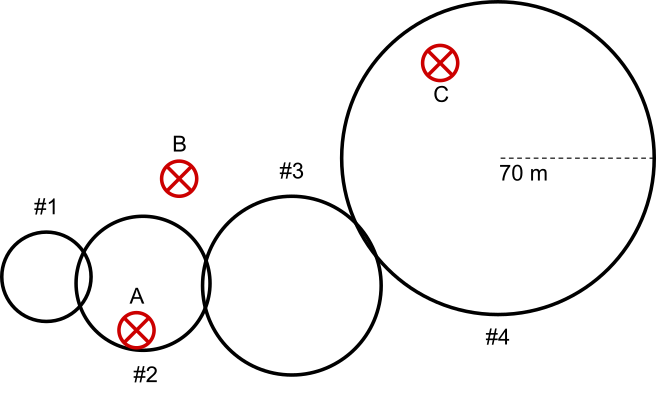
Four fences (1-4) and 3 positions (A, B, C)
The geofence state for each of the 3 positions are:
Position \ Fence state |
1 |
2 |
3 |
4 |
Combined |
|---|---|---|---|---|---|
A |
Outside |
Inside |
Outside |
Outside |
Inside |
B |
Outside |
Outside |
Outside |
Outside |
Outside |
C |
Outside |
Outside |
Outside |
Inside |
Inside |